It's true. After my mostly dismal attempt at walking the Thames Down Link the other week, today I tried to walk section 9 of the London Loop. This is, as the name suggests, a "circular" route through the outskirts of London, split into nice simple chunks. Section 9 is between Hatton Cross and Kingston Bridge, and although the recommended route is to walk it in that direction, I wanted to do the opposite, because I'd just seen Ruth off at Heathrow.
So, at 0630, I emerged from Hatton Cross station. I was better prepared than for the Thames Down Link, having done a bit of map reading but also, crucially, printed out the written directions from the official London Loop website. Granted, as said, they were for the reverse route, but surely all I need to do is swap my lefts and rights. Left?
It worked for a bit. I found some signs. They were useful. That was good. Less useful was the rain that started just as I turned off the A30, but in for a penny in for a pound.
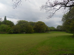
I walked next to the River Crane. I followed the next signs. I crossed a road. I carried on next to the river. I went over a weir. I went over a bridge. I came out on a bit of Hounslow Golf Course ... and I was lost.
The instructions say -- "go straight across the golf course, over the bridge, and turn right". Well I'd just turned left, crossed a bridge, and emerged on the golf course, so I went straight across.
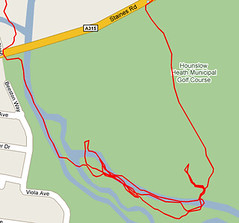
Back to the hole, back to the river, no path. Back to where I emerged, facing it, trying to find a way of standing such that behind me was a path. Couldn't do it. Straight across? At which angle? None of them that I could tell. This charade took a good 30 minutes or so, in the pissing rain, and just annoyed me so much. Where were the signs? Where was the path? Why couldn't I find either? So I walked back down the aforementioned fairway, got to the mound again... and spotted a path next to it that I'd missed first time!
Not the right path. It just took me back out of the golf course onto Staines Road -- the road I'd crossed (correctly) back when I was still on course and hugging the River Crane.
On the road there was a knackers yard and some roadworks. Puddles and rain. Loads of traffic. Just horrible. I walked along it, determined to still walk even if I couldn't do it in somewhat nicer surroundings.
Turns out the directions mention that earlier in the route you cross Staines Road. Since earlier meant later for me, I did actually hold out some hope of rejoining the loop if I just persevered along the road.
At the time, there were two crucial things which I had no idea about -- but do now, having plotted the map of my route. First, my route out of the golf course had been a huge double back. The fact I'd crossed Staines Road earlier was a mystery -- it had just been "a road", and sufficiently further along to look very different. I'd lost my sense of direction, sort of.
Second, there are two Staines Roads around the area. I was on the wrong one.
I figured this out, actually, by the time I got to the outer limits of Hounslow town centre. Here I really thought about giving up properly and just jumping on a bus, but two things stopped me from doing that. I knew where I was (and thus which way to go), and the sun was coming out. The weather being as it was, I thought there was a good chance of a rainbow, and I wanted to photograph it.
No rainbow was forthcoming. Instead I just walked to Whitton, used the community toilet scheme, bought a diet coke, found a park with a "River Crane walk" in it and set off back along that damn fucking river -- though not before spending ~5 minutes staring at the map + information board trying desperately to figure out which way would take me toward Twickenham and which back toward Hatton Cross.
I picked right! But I still got really confused. In a day of pairs, I learnt two things about the River Crane walk. One: there are two routes along it, one "via River Crane" and one via something else. Huh? I don't get it. But anyway, two: the "via River Crane" route hardly sticks near the River Crane at all. I thought I'd been typical me and got lost when I didn't see the river for a while, and especially so when I suddenly found myself next to The Stoop and then in some residential roads. Much to my surprise I then saw a "River Crane Walk" sign on a corner...
... but I didn't care. Enough was enough. It was about 0930 now, I'd expected to be at Kingston or Kingstonabouts but I was just north of Twickenham station, opposite Heatham House, venue of -- perhaps -- Halibutt Sharon's finest ever gig (though the Marquee was pretty sweet too). In the spirit of my old band, then, I stood at a bus stop and waited for a bus. For about 2 minutes. And then I went home and made some pork.
1 comment:
woud u my blog and
Post a Comment